GIS Data Converter3
GIS Data Converter3
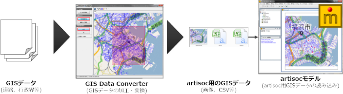
地理的な空間上でエージェントが動作するモデルを作成する際には、これまでは独自にartisocで読み込める形にする必要があるなどデータ整備の煩雑さが大きな課題となっておりました。
最近では地図などの地理情報データを入手しやすくなっていることから、様々なシーンでこれらのデータをシミュレーションに活用することが期待されております。
「GIS Data Converter」は、汎用的なGIS(地理情報)データをartisoc上で利用しやすい形に編集・変換するためのツールです。 付属のGISデータを用いたサンプルモデルを用いることで簡単に地図情報を利用したモデルを構築できます。
ツールの特徴

-
一般的なGISデータの読み込み
Shapefile※1および数値地図25000※2形式に対応
緯度経度座標系、平面直角座標系に対応
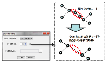
簡易的なデータ補正※3
データの軽量化のために出力するラインの粗さを設定可能(交点以外のリンク構成点を間引きます)
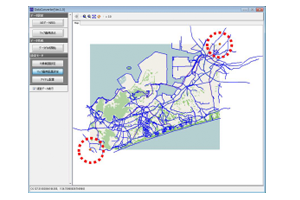
対象範囲の切り出し
シミュレーション対象領域の範囲をGUIで指定可能
背景画像表示機能
一般的な地図画像を背景画像として指定可能
(JPG, PNG, GIF, BMP形式およびワールドファイル.jgwに対応)
artisoc上で背景として利用できる画像を、変換後のシミュレーション用データと対応するように出力
データ変換機能
シミュレーションで利用しやすいデータ形式で出力(Shapefile出力も可能)
サンプルモデル付き
作成したリンクデータ上でエージェントがランダムに移動するモデルです。
artisoc Cloudで作成した「GIS Data Converterのサンプルモデル」
※1.米国のESRI社のGIS標準データ形式です。
※2. 数値地図25000は、国土地理院が発行する市販データです。全国のデータが整備されています。 従来版のフォーマットに対応しており、新規格のJPGISには対応しておりません。
※3. GISデータの形状の編集機能は含みません。
GIS Data Converter 3 の新機能
GIS Data Converter 2(GIS道路データ変換ツール)からの大きな変更点としては、以下の通りです。
-
ラインデータ以外のデータ形状にも対応
従来はラインデータ(道路データ)を対象としていましたが、ラインデータ以外のポイントデータ、ポリゴンデータにも対応しました。
-
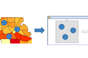
ポリゴンデータのセル分割機能
面的な地図データをartisocのセル空間情報に変換することができます。
-
ポイントの編集機能
ポイントデータについては、ツール上で新しいポイントの追加、必要ないポイントの削除をGUI上で行うことができます。
点の地図データをラインやポリゴンのデータと一緒に編集することができ、エージェントの位置などの設定にも活用できます。 -
データの属性編集機能
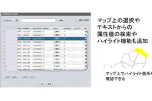
セルのデータやポイントデータの属性値がGUIのクリック操作やテキストボックスの入力で編集できます。
これにより、ツール上でシミュレーションのための数値の設定を行うこともできます。 -
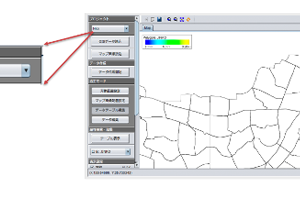
編集中データ保存機能
データの編集を「プロジェクト」単位として保存し管理することができます。また、プロジェクトはプルダウンメニューで随時切り替えることができます。
これにより、編集途中のデータを保存し、様々な編集結果のデータを同時に管理することができます。 -
新機能についての詳細は、こちらの資料をご覧ください
⇒「GISデータ変換ツールバージョンアップのご紹介」

ラインナップ
GIS Data Converterの製品ラインナップは以下の通りです。
| GIS Data Converter 3 for artisoc | |
|---|---|
| 特徴 |
GISデータをartisocで利用しやすいデータ形式に加工します。 |
| 申込方法 |
法人・行政機関ユーザ向け artisoc本体をご購入いただいていることが条件となります。 |
|
教育向け 教育機関において研究目的に利用する教職員の方が販売対象となります。 1ライセンスにつきPC3台までご利用いただけます。 |
|
動作環境
Microsoft Windows 11/10
チュートリアル
詳細な使用方法については、下記のチュートリアル資料の後半部をご参照ください。
artisoc中級チュートリアル GISデータを利用したシミュレーションモデル作成講習
デモ
GIS_Data_Converterには、出力されたデータを利用するサンプルモデルが付属しております。
サンプルモデルでは、出力したノードデータ、リンクデータ等の道路情報や設備データをもとに道路を作成し、作成された道路上を各エージェントがランダムに移動します。
出力データ形式の確認や、利用イメージのご確認にご使用ください。
artisoc4向けサンプルモデルのダウンロードはこちらから
artisoc Cloudで作成した「GIS Data Converterのサンプルモデル」